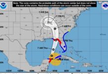
Florida’s Gulf Coast is dealing with the devastation left behind by Hurricane Idalia, which is now a post-tropical cyclone—but may gather strength again—and has moved into the open Atlantic after dumping heavy rains on the Carolinas.
With its status as a strong Category 3 when it made landfall on Florida’s Big Bend region early Wed., Aug. 30, Idalia is officially the strongest hurricane this century to hit that area of the Gulf Coast, the last one being an unnamed storm in 1896. The “Big Bend” is the curve defining the transition zone between the panhandle and the peninsula, sparsely populated and laced with marshland, rivers and freshwater springs.
Major structural damage was reported in the Big Bend towns of Keaton Beach, Perry and Cedar Key, FL, with trees and power lines down, and some homes and businesses completely wiped out. As is the case with many violent storms, intact houses on stilts stood beside piles of splintered woodpiles that had once been someone’s home.
Meanwhile, flooding from storm surge stretched about 200 miles along Florida’s west coast. South of the most severely impacted area, major flooding was reported in Pasco County as well as in the Tampa Bay area, where near-record water levels resulted from a 5-foot surge.
Airports that had closed in advance of the storm’s arrival were open as of Thursday morning, including Tampa Bay International Airport, St. Pete-Clearwater International Airport, Sarasota Bradenton International Airport and Tallahassee International Airport. However, because of closures and flight delays, including flight cancellations in Charlotte on Wednesday, passengers are advised to check with their individual airlines regarding flight status.
At press time, Idalia was gathering strength and could reform as a tropical storm, putting Bermuda under a tropical storm watch. Idalia was projected to be at its closest point to the island—about 70 miles to the island’s south-southeast—by 10 p.m. on Sept. 2.
For more information, visit nhc.noaa.gov.


